Antarctica: Southern Ocean floor mapped in greatest ever detail
Online Desk
07 Jun 2022 23:45 PM
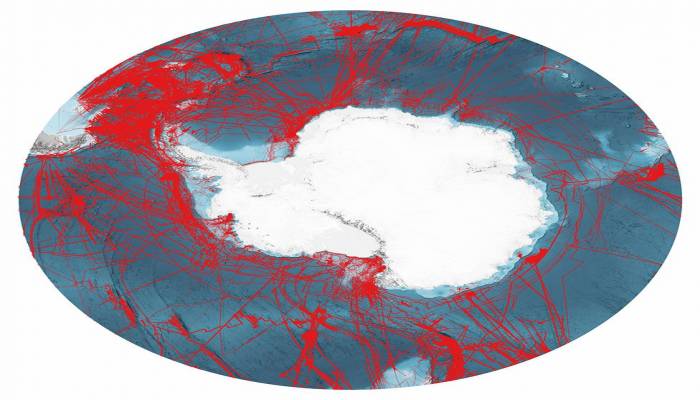
Scientists have made the most precise map yet of the mountains, canyons and plains that make up the floor of Antarctica's encircling Southern Ocean.
Covering 48 million sq km, this chart for the first time details a new deepest point - a depression lying 7,432m down called the Factorian Deep, reports BBC.
Knowledge of the shape of the ocean's bottom is essential to safe navigation, marine conservation, and understanding Earth's climate and geological history.
But we still have much to learn.
Vast tracts of terrain have never been properly surveyed.
The International Bathymetric Chart of the Southern Ocean (IBCSO) has taken five years to compile and updates the first attempt at a comprehensive map, which was published in 2013.
The IBCSO project and others like it around the world are gradually filling in the gaps in our scant knowledge of the bottom of the world's oceans.
Ships and boats are being encouraged to routinely turn on their sonar devices to get depth (bathymetric) measurements; and governments, corporations, and institutions are being urged not to hide away data and put as much as possible into the public domain. This is paying dividends.
The new map covers all the Southern Ocean floor poleward of 50 degrees South. If you divide its 48 million sq km (18.5 million sq miles) into 500m grid squares, 23% of these cells now have at least one modern depth measurement.
That's a big improvement on nine years ago.
Back then, IBCSO began only at 60 degrees South, and less than 17% of its grid boxes had a modern measurement.
"You have to realise just what the change from 60 degrees to 50 degrees means; we've more than doubled the area of the chart," said Dr Boris Dorschel from Germany's Alfred Wegener Institute.
"So, we've increased the area coverage, but we've also increased the data density, because, in parallel, we've kept on acquiring new data and knocking on doors to free up existing data," he told BBC News.
Much of the information in the chart comes from the ice-strengthened ships that support scientific endeavours in Antarctica, including from the UK's former polar ship, the RRS James Clark Ross. (In future, this British contribution will come from its successor, the RRS Sir David Attenborough, affectionately known as Boaty McBoatface.)
As these vessels shuttle back and forth between the White Continent and the likes of Chile, South Africa and Tasmania - their echosounders make a habit of surveying the submerged terrain below.
And this activity is increasingly coordinated, with research organisations from different nations working together to try to offset slightly the routes taken by their icebreakers.

